Yijian Zeng

and 7 more

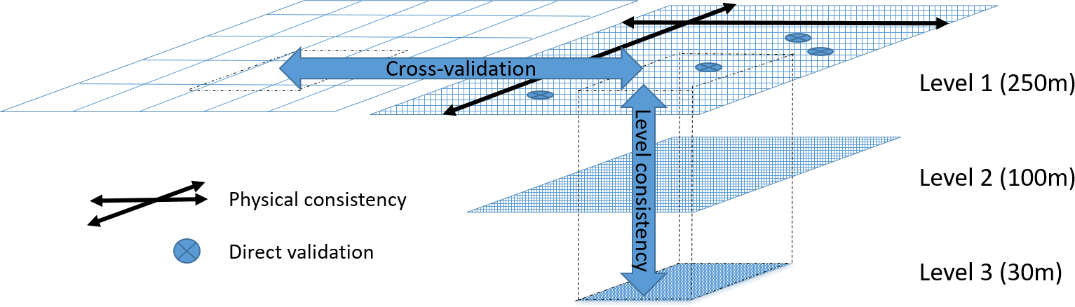
The assessment of soil health has evolved from focusing primary on agricultural productivity to an integrated evaluation of soil biota and biotic processes that impact soil properties. Consequently, soil health assessment has shifted from a predominantly physico-chemical approach to incorporating ecological, biological and molecular microbiology methods. These methods enable a comprehensive exploration of soil microbial community properties and their responses to environmental changes arising from climate change and anthropogenic disturbances. Despite the increasing availability of soil health indicators (physical, chemical, and biological), a holistic mechanistic linkage between indicators and soil functions across multiple spatiotemporal scales has not yet been fully established. This article reviews the state-of-the-art of soil health monitoring, focusing on understanding how soil-microbiome-plant processes contribute to feedback mechanisms and causes of changes in soil properties, as well as the impact these changes have on soil functions. Furthermore, we survey the opportunities afforded by the soil-plant digital twin approach, an integrative framework that amalgamates process-based models, Earth Observation data, data assimilation, and physics-informed machine learning, to achieve a nuanced comprehension of soil health. This review delineates the prospective trajectory for monitoring soil health by embracing a digital twin approach to systematically observe and model the soil-plant system. We further identify gaps and opportunities, and provide perspectives for future research for an enhanced understanding of the intricate interplay between soil properties, soil hydrological processes, soil-plant hydraulics, soil microbiomes, and landscape genomics.

Andreas Colliander

and 47 more

NASA’s Soil Moisture Active Passive (SMAP) mission has been validating its soil moisture (SM) products since the start of data production on March 31, 2015. Prior to launch, the mission defined a set of criteria for core validation sites (CVS) that enable the testing of the key mission SM accuracy requirement (unbiased root-mean-square error <0.04 m3/m3). The validation approach also includes other (“sparse network”) in situ SM measurements, satellite SM products, model-based SM products, and field experiments. Over the past six years, the SMAP SM products have been analyzed with respect to these reference data, and the analysis approaches themselves have been scrutinized in an effort to best understand the products’ performance. Validation of the most recent SMAP Level 2 and 3 SM retrieval products (R17000) shows that the L-band (1.4 GHz) radiometer-based SM record continues to meet mission requirements. The products are generally consistent with SM retrievals from the ESA Soil Moisture Ocean Salinity mission, although there are differences in some regions. The high-resolution (3-km) SM retrieval product, generated by combining Copernicus Sentinel-1 data with SMAP observations, performs within expectations. Currently, however, there is limited availability of 3-km CVS data to support extensive validation at this spatial scale. The most recent (version 5) SMAP Level 4 SM data assimilation product providing surface and root-zone SM with complete spatio-temporal coverage at 9-km resolution also meets performance requirements. The SMAP SM validation program will continue throughout the mission life; future plans include expanding it to forested and high-latitude regions.

Megan Blatchford

and 7 more

The FAO Water Productivity Open Access Portal (WaPOR) offers continuous actual evapotranspiration and interception (ETIa-WPR) data at a 10-day basis across Africa and the Middle East from 2009 onwards at three spatial resolutions. The continental level (250m) covers Africa and the Middle East (L1). The national level (100m) covers 21 countries and four river basins (L2). The third level (30m) covers eight irrigation areas (L3). To quantify the uncertainty of WaPOR version 2 (V2.0) ETIa-WPR in Africa, we used a number of validation methods. We checked the physical consistency against water availability and the long term water balance and then verify the continental spatial and temporal trends for the major climates in Africa. We directly validated ETIa-WPR against in-situ data of 14 eddy covariance stations (EC). Finally, we checked the level consistency between the different spatial resolutions. Our findings indicate that ETIa-WPR is performing well, but with some noticeable overestimation. The ETIa-WPR is showing expected spatial and temporal consistency with respect to climate classes. ETIa-WPR shows mixed results at point scale as compared to EC flux towers with an overall R2 of 0.61, and a root mean square error of 1.04 mm/day. The level consistency is very high between L1 and L2. However, the consistency between L1 and L3 varies significantly between irrigation areas. In rainfed areas, the ETIa-WPR is overestimating at low ETIa-WPR and underestimating when ETIa is high. In irrigated areas, ETIa-WPR values appear to be consistently overestimating ETa. The soil moisture content, the input of quality layers and local advection effects were some of the identified causes. The quality assessment of ETIa-WPR product is enhanced by combining multiple evaluation methods. Based on the results, the ETIa-WaPOR dataset is of enough quality to contribute to the understanding and monitoring of local and continental water processes and water management.